Ancient Persian cities functioned not as isolated urban fortresses, but as an integrated, polycentric network of specialized imperial capitals, administrative hubs, and regional satrapal centers spanning the Iranian plateau, Mesopotamia, Anatolia, and the Levant. Unlike earlier Near Eastern powers governed from a single, static metropolis (such as Nineveh or Babylon), the Achaemenid Empire (c. 550–330 BCE) pioneered a mobile, seasonal capital system. The imperial court rotated between Pasargadae (the ancestral dynastic seat), Susa (the permanent administrative and bureaucratic chancellery), Ecbatana (the northern strategic and summer capital), and Persepolis (the monumental ceremonial and treasury center), supported by major incorporated cosmopolitan centers like Babylon, Bactra, and Sardis. This urban network unified over five million square kilometers through standardized municipal archives, royal storehouses, subterranean hydraulic networks (qanats), and monumental terrace architecture.
Chronological Milestones: The Evolution and Urbanization of Ancient Persian Cities
| Era & Date | Urban Phase & Foundation | Primary Archaeological Sites | Urban Morphology & Historical Milestones |
| Proto-Urban & Elamite Substratum (c. 3000–550 BCE) | Pre-Achaemenid Urban Continuity | Susa, Anshan (Tal-e Malyan), Ecbatana (Hamadan) | Dense, multi-layered tell settlements characterized by high mudbrick citadels, Elamite administrative cuneiform archives, and continuous urban occupation linking lowlands to the Zagros plateau. |
| Early Imperial Genesis (c. 559–530 BCE) | The Open-Landscape Dynastic Seat | Pasargadae (Batrakataš) | Transition from dense walled cities to a decentralized, low-density “garden city” model; introduction of megalithic ashlar stone pavilions, the Talg-e Takht royal terrace, and the earliest formal Chahar Bagh hydraulic estates. |
| Imperial Consolidation & Chancellery Zenith (c. 522–486 BCE) | The Dual Administrative-Ceremonial Axis | Susa (Šušan), Persepolis (Pārsa), Babylon | Construction of massive artificial terrace platforms (takht), monumental hypostyle halls (apadanas), subterranean bedrock drainage networks, and specialized archives (Persepolis Fortification and Treasury Tablets). |
| Satrapal Urban Network Expansion (c. 486–350 BCE) | Provincial & Strategic Administrative Hubs | Sardis, Memphis, Bactra, Damascus, Gordion, Sidon | Fortification of regional satrapal seats (bāji-stations); integration of local urban traditions with Persian administrative compounds, formal paradeisoi (walled estates), and imperial garrison barracks. |
| Post-Achaemenid Transformation (330 BCE – 224 CE+) | Hellenistic & Parthian Re-Urbanization | Seleucia-on-the-Tigris, Ctesiphon, Hecatompylos | Partial Hellenistic restructuring of former Persian administrative centers, followed by the revival of Iranian circular urban planning and royal hunting enclosures under Parthian and Sasanian rule. |
Conceptual Architecture of the Persian Urban Network
The Polycentric Capital System and Seasonal Itinerancy of the Imperial Court
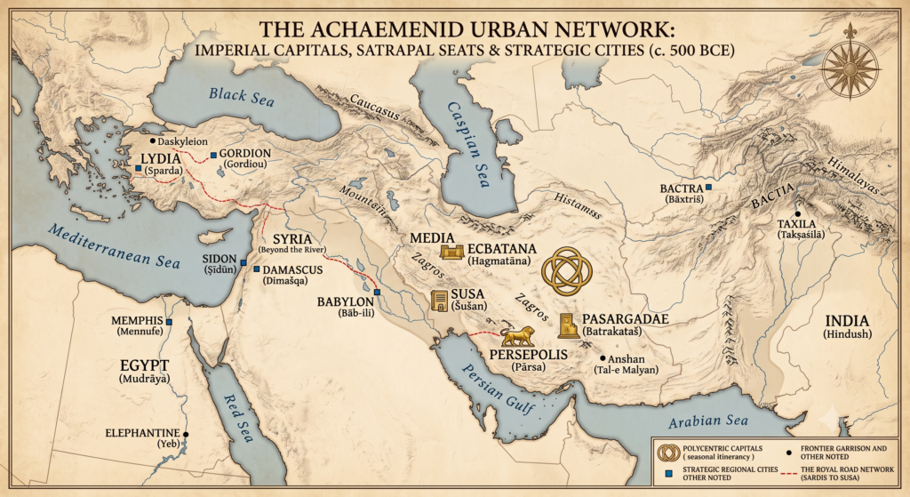
Historical map illustrating the integrated, polycentric urban network of the Achaemenid Persian Empire (c. 500 BCE), visualizing the itinerant seasonal court rotation between the four main imperial capitals, strategic regional hubs, and satrapal centers.
Unlike classical Mediterranean city-states (poleis) or centralized river-valley autocracies, the Achaemenid Empire functioned through a polycentric urban topology. The empire possessed no single, static capital. Instead, imperial governance operated as an itinerant court system (the mobile court), where the king, royal chancellery (dīwān), high judges, treasury officials, and elite military units (the Ten Thousand Immortals) moved systematically between distinct administrative and ceremonial epicenters according to seasonal, agricultural, and geopolitical cycles.
       [WINTER]                           [SPRING]                           [SUMMER]
  SUSA / BABYLON                     PERSEPOLIS / PASARGADAE                 ECBATANA
(Lowland Chancellery &              (Highland Ceremonial Rituals &      (Cool Highland Plateau,
 Administrative Logistics)             Treasury Distribution)           Northern Strategic Base)
The Mechanics of Seasonal Court Rotation
Classical historians (notably Xenophon in the Cyropaedia and Strabo in Geographica) documented this rotation, which was dictated by environmental reality as well as political strategy:
- Winter Residence (Susa and Babylon): Located in the alluvial lowlands of Khuzestan and Mesopotamia, Susa and Babylon provided warm winter climates and access to extensive riverine trade routes. Susa functioned as the bureaucratic engine room, housing the primary imperial archives and issuing royal decrees in Elamite, Old Persian, and Imperial Aramaic.
- Spring Equinox and Dynastic Renewal (Persepolis and Pasargadae): As temperatures rose on the plains, the court traversed the Zagros Mountains to the high plateau of Fars (Pārsa). In Persepolis, the monarch received formal tribute delegations during seasonal festivities and oversaw religious dedications at the ancestral monuments of Pasargadae.
- Summer Retreat (Ecbatana / Hamadan): To escape the scorching summer heat of the southern plains and central deserts, the court relocated north to the high-altitude, fertile slopes of Mount Alvand in Media. Ecbatana provided an ideal staging ground for military mobilizations toward the northern and eastern frontiers.
This geographic mobility prevented administrative stagnation, reinforced royal authority across diverse satrapies, and distributed the immense economic burden of maintaining the royal retinue across multiple agricultural provinces.
Comprehensive Gazetteer: Major Cities and Urban Settlements of Ancient Persia
To understand the urban breadth of the empire, ancient Persian cities are classified below by their primary institutional functions, archaeological names, and strategic roles across the realm:
1. Imperial & Dynastic Capitals (The Core Quadrumvirate)
- Persepolis (Pārsa / Takht-e Jamshid)
- Modern Location: Fars Province, Iran.
- Primary Function: Ceremonial, ideological, and dynastic capital; central imperial treasury and tribute repository.
- Key Features: Monumental stone platform (takht), Apadana audience hall, Gateway of All Nations, Throne Hall (Hall of 100 Columns), and the Persepolis Fortification Archive (tens of thousands of cuneiform administrative tablets).
- Susa (Šušan / Shush)
- Modern Location: Khuzestan Province, Iran.
- Primary Function: Administrative heart and primary imperial chancellery; terminal hub of the Royal Road from Sardis.
- Key Features: Palace of Darius with famous glazed polychrome siliceous brick friezes (Frieze of Archers, Winged Griffins), monumental hypostyle audience hall, and continuous urban occupation dating back to the 4th millennium BCE.
- Pasargadae (Batrakataš)
- Modern Location: Fars Province, Iran.
- Primary Function: Ancestral dynastic seat, coronation sanctuary, and imperial memorial center.
- Key Features: Megalithic gabled Tomb of Cyrus, Talg-e Takht stone terrace platform, Residential Palace (Palace P), and the earliest formal quadripartite royal paradise garden (Chahar Bagh).
- Ecbatana (Hagmatāna / Hamadan)
- Modern Location: Hamadan Province, Iran.
- Primary Function: Strategic northern capital, royal summer residence, and ancestral capital of Media.
- Key Features: Elevated seven-ringed fortified citadel described by Heródoto, gold- and silver-plated cedar palatial complexes, and major crossroads commanding the Great Khorasan Road leading to Central Asia.
2. Cosmopolitan Metropolises & Economic Hubs
- Babylon (Bāb-ili / Bābiru)
- Modern Location: Hillah, Babil Governorate, Iraq.
- Primary Function: Principal commercial, financial, and astronomical metropolis of the western empire.
- Key Features: Location of the royal Southern and Northern Palaces, the Esagila temple complex of Marduk, banking family estates (such as the House of Egibi), and the issuing site of the Cyrus Cylinder (539 BCE).
- Anshan (Tal-e Malyan)
- Modern Location: Fars Province, Iran.
- Primary Function: Ancient Elamite-Persian proto-urban center; ancestral territorial title of the early Teispid and Achaemenid royal lineage (Kings of Anshan).
- Key Features: Extensive mudbrick administrative complexes and stratigraphic continuity between highland pastoralism and centralized statecraft.
3. Satrapal Seats & Regional Provincial Capitals
- Sardis (Sparda)
- Modern Location: Manisa Province, Turkey.
- Primary Function: Westernmost satrapal capital (Satrapy of Lydia) and command center for Aegean diplomacy and military operations.
- Key Features: Fortified acropolis, western terminus of the 2,700-kilometer Royal Road, Persian paradeisos (pleasure estate), and primary mint for gold darics and silver sigloi in the west.
- Bactra (Bāxtriš / Balkh)
- Modern Location: Balkh Province, Afghanistan.
- Primary Function: Eastern imperial stronghold, satrapal seat of Bactria, and commercial crossroads connecting the Iranian plateau with the Indus Valley and Central Asian steppe networks.
- Key Features: Massive earthen ramparts (Bala Hissar), major silver metallurgy production, and the strategic gatekeeper of the northeastern frontier.
- Memphis (Mennufe / Mēp-iš)
- Modern Location: Giza Governorate, Egypt.
- Primary Function: Satrapal administrative capital of Egypt (Mudrāya).
- Key Features: Persian military garrison quarters, administrative chancellery keeping records in Demotic and Aramaic, and royal patronage of the Sacred Apis Bull cult.
- Damascus (Dimašqa)
- Modern Location: Damascus, Syria.
- Primary Function: Administrative seat for the satrapy of Beyond the River (Ebir-Nāri / Syria-Phoenicia-Palestine).
- Key Features: Central redistribution center for Levantine grain, timber, and wine; military logistical base supporting western Mediterranean campaigns.
- Gordion (Gordiou)
- Modern Location: Ankara Province, Turkey.
- Primary Function: Provincial administrative seat of Hellespontine Phrygia (Daskyleion network).
- Key Features: Rebuilt Persian palatial compound, defensive citadel, and key regional customs post along the Royal Road.
- Sidon (Ṣīdūn)
- Modern Location: South Governorate, Lebanon.
- Primary Function: Primary naval satrapal base, Phoenician maritime hub, and royal timber staging center.
- Key Features: Extensive royal paradeisos where kings and satraps oversaw the construction of imperial triremes using Mount Lebanon cedar.
4. Fortified Garrisons, Frontiers, and Strategic Waystations
- Elephantine (Yeb)
- Modern Location: Aswan, Egypt.
- Primary Function: Southernmost frontier border fortress on the First Cataract of the Nile.
- Key Features: Station of a multi-ethnic mercenary garrison (notably the Judeo-Aramaic military colony documented in the Elephantine Papyri), guarding against Kushite expansion.
- Daskyleion (Daskyleion)
- Modern Location: Balıkesir Province, Turkey.
- Primary Function: Satrapal estate of Hellespontine Phrygia governing the Marmara and Black Sea straits.
- Key Features: Substantial imperial Persian archives (hundreds of bullae clay seal impressions), Zoroastrian-style funerary reliefs, and formal landscaped gardens.
- Taxila (Takṣaśilā)
- Modern Location: Punjab, Pakistan.
- Primary Function: Eastern frontier satrapal administrative center for the provinces of Hindush and Gandhāra.
- Key Features: The Bhir Mound excavations, proving Persian urban grid systems, Aramaic administrative inscriptions, and commercial transfer points for Indus spices, ivory, and cotton.
Urban Infrastructure, Hydraulic Engineering, and Municipal Administration
The planning of ancient Persian cities differed fundamentally from the dense, chaotic street patterns typical of ancient Near Eastern settlements. Achaemenid urban planners prioritized monumental terracing, strict axial alignment, low-density suburban integration, and advanced subterranean hydraulic engineering. Rather than confining entire populations within suffocating defensive walls, major Persian urban centers were conceived as expansive landscape complexes where monumental palatial platforms (takht), administrative archives, military barracks, artisan settlements, and agricultural estates (paradeisoi) coexisted in a carefully balanced ecosystem.
       ┌─────────────────────────────────────────────────────────────┐
       │             ACHAEMENID URBAN SPATIAL HIERARCHY             │
       ├─────────────────────────────────────────────────────────────┤
       │ 1. THE SACRED/ROYAL PLATFORM (Ashlar Masonry, High Citadel)  │
       │ 2. CHANCELLERY & ARCHIVAL SECTOR (Cuneiform/Aramaic Bureaus) │
       │ 3. MILITARY GARRISON & BARRACKS (Standing Core Troops)      │
       │ 4. SUBURBAN RESIDENTIAL & WORKSHOP ZONES (Craft Quarters)   │
       │ 5. PERI-URBAN PARADISE ESTATES (Irrigated Walled Orchards)  │
       └─────────────────────────────────────────────────────────────┘
The Subterranean Hydraulic Revolution: Qanats and Urban Water Management
Sustaining major populations and lush royal estates in the arid highland valleys of Fars, Media, and Central Asia was only possible through revolutionary hydraulic engineering. Persian engineers perfected and expanded the Qanat (in Old Persian, likely related to subterranean conduits), a gravity-fed water management system that transformed desert plateaus into fertile urban centers:
- Mother Well Extraction (Mādar-čāh): Engineers identified deep alluvial aquifers in the foothills of surrounding mountain ranges, excavating a vertical mother well to tap the subterranean water table.
- Subterranean Graded Channels: From the mother well, miners cut a gently sloping horizontal tunnel through solid earth and bedrock over distances extending up to dozens of kilometers. Because the water flowed entirely underground, evaporation losses were virtually zero, even during scorching summer temperatures exceeding 40°C.
- Vertical Aeration & Maintenance Shafts: At regular intervals of 20 to 50 meters, vertical shafts were sunk from the surface to provide oxygen to the subterranean excavators, remove excavated soil, and allow permanent municipal maintenance crews to clear silt blockages.
- Intra-Urban Distribution Networks: Upon reaching the city perimeter, the qanat divided into an intricate network of covered stone channels (jūb), feeding fresh, mountain-filtered drinking water directly into palace courtyards, public fountains, cisterns (āb-anbārs), and subterranean cooling chambers.
| Hydraulic Component | Engineering Mechanism | Municipal / Urban Function |
| Qanat Conduit System | Gravity-fed underground channels with a slope of 1:1000 to 1:1500. | Continental transport of potable snowmelt water without surface evaporation loss. |
| Bedrock Drainage Tunnels | Subterranean stone masonry channels up to 2.5 meters high cut beneath terrace floors. | Evacuation of torrential winter mountain runoff, preventing foundation erosion and wall collapse. |
| Subterranean Cisterns (Āb-Anbār) | Deep, domed brick reservoirs insulated with waterproof mortar (sārūj). | Year-round municipal storage of ice and cold water for domestic consumption. |
| Piped Terracotta Conduits | Interlocking ceramic pipes with lime sealant. | Pressurized interior water supply delivering water to upper-level palace rooms and gardens. |
Beneath the monumental platform of Persepolis, excavations led by the Oriental Institute of the University of Chicago uncovered more than two kilometers of subterranean drainage galleries carved directly out of the living limestone bedrock before the monumental structures above were even built. These tunnels were large enough for maintenance workers to walk upright through them, functioning as a combined storm sewer and foundational preservation system that has kept the monumental terraces intact for over two millennia.
The Municipal Bureaucracy: Lessons from the Persepolis Fortification Archive
Our understanding of how a Persian city actually functioned on a day-to-day basis was revolutionized by the discovery of the Persepolis Fortification Tablets (PFT) and Persepolis Treasury Tablets (PTT)—a corpus of tens of thousands of clay cuneiform tablets written primarily in Elamite, with additions in Imperial Aramaic, Old Persian, Phrygian, and Greek.
These administrative archives reveal an extraordinarily sophisticated municipal state apparatus governing labor, rations, taxation, and travel:
[Royal Decree Issued] ➔ [Chancellery Scribe Records in Elamite/Aramaic] ➔ [Sealed with Official Cylinder Seal] ➔ [Storehouse Dispenses Grain/Wine/Livestock] ➔ [Auditor Verifies Record on Clay Ledger]
- The Ration Redistribution System (Kurtaš): Urban labor was not performed primarily by chattel slaves, but by state-dependent specialized workforces known as kurtaš. Scribes recorded exact monthly rations of barley, wine, beer, dates, flour, and sheep distributed to male, female, and child workers based on their technical skill level and productivity.
- Gender-Differentiated Labor & Maternity Benefits: The tablets prove that female artisans frequently commanded workshops and received equal—and sometimes superior—rations to their male counterparts based on their specialized skills (notably in high-end textile and treasury work). Scribes also documented specialized postpartum rations of grain and wine (maternity allowances) granted to working mothers within royal municipal workshops.
- The Imperial Travel Authorization Network (Miyatka): Anyone traveling through imperial cities along the highway network—from high-ranking satraps to foreign artisan groups—carried a sealed passport warrant (miyatka). Upon entering city gates, the local chancellery examined the seal, registered their arrival in municipal ledger tablets, and authorized regional granaries and royal storehouses to dispense exact daily food rations for the travelers and their pack animals.
- Storage and Urban Silos: Persian municipal centers functioned as colossal redistribution depots. Excavations at Susa, Pasargadae, and Daskyleion have confirmed massive mudbrick granaries and wine cellars sealed with royal bureaucratic stamps, designed to provision standing military garrisons and support the regional urban populace during localized crop failures.
Step Into the Ancient World: A Day in the Royal Quarter of Susa
Imagine standing in the lower gatehouse of Susa at midday in the heat of early autumn.
The ambient noise of the metropolis is overwhelming. Down in the craft quarters flanking the Chaour River, the rhythmic clatter of horizontal textile looms mixes with the metallic ringing of bronze hammers from the armory workshops. The air is thick with competing scents: the sharp, mineral tang of wet clay from thousands of drying cuneiform tablets, the sweet resin of boiling bitumen imported from Hit to waterproof palatial foundations, and the rich, roasted fragrance of sesame oil and spiced flatbread coming from the municipal bakeries.
[Lower Riverbank Workshops] ➔ [Ascent Through Fortified Gateways] ➔ [Central Administrative Courtyard] ➔ [Shaded Interior Hypostyle Porticos]
At the western gate of the citadel platform, a team of twenty Elamite and Babylonian scribes sits cross-legged under an awning of heavy linen. Before them stands a line of travelers awaiting entry: a royal messenger (pirradazish) holding a sealed parchment cylinder, a merchant caravan from Bactria carrying sacks of unworked lapis lazuli, and a group of Egyptian stonecutters assigned to repair the terrace revetments.
A scribe dips a carved reed stylus into water and rapidly impresses wedge-shaped cuneiform characters across a moist, palm-sized clay tablet:
“30 QA of barley, dispensed from the central storehouse of Susa, issued to Hapan, the royal courier, traveling with two horses under the seal of Satrap Artaphernes. Month of Bagayadi, Year 14.”
He rolls an intricately carved agate cylinder seal across the wet clay, leaving a raised relief of the King spearing a rampant winged monster. The tablet is handed to a junior runner, who vanishes down the long vaulted corridor toward the subterranean storehouse vaults.
Passing through the inner administrative gate, you enter the grand courtyard of Darius’s palace. Here, the stifling desert heat suddenly drops. Cool air circulates from subterranean qanat shafts venting directly into the shaded porticos. Towering above you, the palace walls gleam with vibrant polychrome glazed bricks: rows of royal spearmen in pleated yellow and purple tunics, golden lions pacing across turquoise borders, and winged sphinxes standing guard beneath the protective disc of Ahuramazda.
In this space, the city does not feel like a chaotic settlement—it feels like a meticulously engineered administrative machine where millions of lives, across thousands of leagues, are coordinated with the stroke of a reed upon clay.
Aquí tienes el bloque final de cierre para Ancient Persian Cities, desarrollado con el mismo rigor académico, profundidad historiográfica y optimización técnica para SEO:
The Urban and Spatial Legacy of Persian Cities
The polycentric urban network established by the Achaemenid Empire fundamentally altered the evolution of urbanism across the ancient and medieval worlds. Rather than disappearing after the Macedonian conquest of 330 BCE, Persian spatial planning principles, hydraulic infrastructure, and administrative zoning were actively adopted and transformed by successor dynasties across the Near East, Central Asia, and the Mediterranean.
       Achaemenid Polycentric & Landscape Urbanism
                           ↓
       Hellenistic Administrative Continuity (Seleucids)
                           ↓
       Parthian Circular Fortress Cities (Ctesiphon, Hatra)
                           ↓
       Sasanian Geometric & Hydraulic Urban Planning (Gundeshapur, Bishapur)
                           ↓
       Classical Islamic Urban Topography & Garden Estates (Isfahan, Baghdad)
| Historical Era & Successor State | Inherited Urban & Engineering Element | Architectural & Spatial Transformation |
| Seleucid Empire (312–63 BCE) | Satrapal bureaucratic chancellery compounds and cadastral road networks. | Integration of Greek grid systems (Hippodamian plan) within established Persian administrative capitals such as Susa and Babylon. |
| Parthian Empire (247 BCE – 224 CE) | Seasonal court itinerancy and radial defensive military architecture. | Evolution of mobile royal courts moving between Ctesiphon, Hecatompylos, and Ecbatana; development of circular fortified cities. |
| Sasanian Empire (224–651 CE) | Subterranean qanat networks, monumental terracing, and chahar bagh axes. | Engineering of major planned industrial, agricultural, and university cities (such as Gundeshapur and Bishapur) centered on royal hunting preserves. |
| Classical Islamic Urbanism (750 CE+) | Integrated hydraulic conduits, quadripartite garden plazas, and municipal administrative divisions. | Direct layout inspiration for the Round City of Baghdad and the monumental public garden-city planning of Safavid Isfahan (Naqsh-e Jahan). |
Key Takeaways
- Polycentric Capital System: The Persian Empire operated without a single, static capital, relying instead on a seasonal network of four primary royal centers: Susa (administrative/chancellery), Persepolis (ceremonial/treasury), Pasargadae (ancestral dynastic seat), and Ecbatana (strategic/summer residence).
- The Itinerant Court: The King of Kings and his high bureaucratic apparatus (dīwān) rotated between lowlands and highland plateaus according to seasonal climate cycles, strategic frontier needs, and religious renewal festivals.
- Landscape & Open Urban Planning: Achaemenid urbanism rejected cramped, high-density walled grids, prioritizing expansive landscape complexes that integrated elevated ashlar terraces (takht), monumental hypostyle halls (apadanas), craft quarters, and walled paradise estates (paradeisoi).
- Subterranean Hydraulic Networks: Urban survival in arid highland valleys was secured through the Qanat system—gravity-fed underground channels that transported mountain aquifer water across long distances without surface evaporation losses.
- Persepolis Bedrock Drainage: Monumental platforms featured kilometers of subterranean limestone storm tunnels carved directly into living bedrock, preventing erosion and preserving palatial foundations for over 2,500 years.
- Epigraphic Evidence of Municipal Bureaucracy: The Persepolis Fortification and Treasury Tablets document a sophisticated municipal welfare and ration system (kurtaš), complete with maternity benefits for female artisans and official travel warrants (miyatka).
- Enduring Urban Blueprint: Persian hydraulic engineering, administrative zoning, and quadripartite garden design formed the spatial foundation for later Hellenistic, Sasanian, and classical Islamic cities.
Frequently Asked Questions
What was the capital of the Persian Empire?
The Persian Empire did not have a single capital. It operated through a polycentric seasonal system consisting of four major imperial capitals:
- Susa (Šušan): The primary administrative and bureaucratic center.
- Persepolis (Pārsa): The monumental ceremonial capital and royal treasury.
- Pasargadae (Batrakataš): The ancestral dynastic seat founded by Cyrus the Great.
- Ecbatana (Hagmatāna): The northern strategic base and summer residence.
Additionally, cosmopolitan economic hubs like Babylon and western satrapal capitals like Sardis functioned as vital administrative headquarters.
What is the oldest city in ancient Persia?
Susa (Shush) is one of the oldest continuously inhabited urban settlements in the world, with archaeological occupational layers dating back to c. 4200–4000 BCE. Originally a major Elamite urban center, it was later chosen by Darius the Great as the administrative capital of the Achaemenid Empire due to its strategic position connecting the Mesopotamian lowlands with the Iranian plateau.
What cities were in ancient Persia?
Major cities across the Achaemenid realm included imperial capitals (Persepolis, Susa, Pasargadae, Ecbatana), ancient economic metropolises (Babylon, Anshan), key satrapal capitals (Sardis in Lydia, Bactra in Central Asia, Memphis in Egypt, Damascus in Syria), and frontier garrison centers (Taxila in Gandhara, Elephantine in Egypt, and Daskyleion in Phrygia).
Why was Persepolis built if Susa was already the administrative capital?
While Susa managed the daily bureaucratic correspondence and diplomatic dispatches of the empire, Persepolis was conceived as an ideological, dynastic, and ceremonial center. Located in the ancestral Persian homeland of Fars, it housed the vast imperial treasury and hosted major state events, such as the New Year festival (Nowruz), where delegates from subject nations brought formal tribute to the monarch.
How did ancient Persian cities obtain fresh water in arid regions?
Ancient Persian cities utilized the Qanat system—an advanced network of gently sloping subterranean aqueducts that channeled groundwater from mountain aquifers straight into urban centers. Because these channels ran entirely underground, water was protected from desert heat and evaporation, supplying palace fountains, municipal cisterns (āb-anbārs), and agricultural gardens year-round.
What were the Persepolis Fortification Tablets?
The Persepolis Fortification Tablets are an archive of tens of thousands of administrative cuneiform clay tablets (dating c. 509–493 BCE) discovered within the fortification walls of Persepolis. Written primarily in Elamite, they provide detailed bureaucratic records of food rations, labor compensation (kurtaš), state travel permits (miyatka), and maternity allowances across the royal municipal administration.
Further Reading
- Encyclopaedia Iranica – Achaemenid Capitals: Susa, Persepolis, Pasargadae, and Ecbatana
- The Oriental Institute of the University of Chicago – Persepolis Fortification Archive Project
- World History Encyclopedia – The Great Cities of the Achaemenid Persian Empire
- The British Museum – Ancient Iranian Urban Centers and the Middle East Department
- UNESCO World Heritage Centre – Archaeological Site of Pasargadae and the City of Susa