What Were the Sumerian Cities?
The Sumerian cities of southern Mesopotamia (modern-day southern Iraq) were the world’s first true urban centers, emerging during the Uruk Period in the fourth millennium BCE (c. 4000–3100 BCE). Unlike unified territorial empires, Sumerian civilization functioned as a decentralized network of autonomous city-states (uru in Sumerian).
Each city-state operated with its own sovereign monarch (En, Ensi, or Lugal), a dedicated patron deity residing in a central stepped temple (ziggurat), specialized social hierarchies, and an extensive agricultural hinterland sustained by Euphrates and Tigris canal engineering.
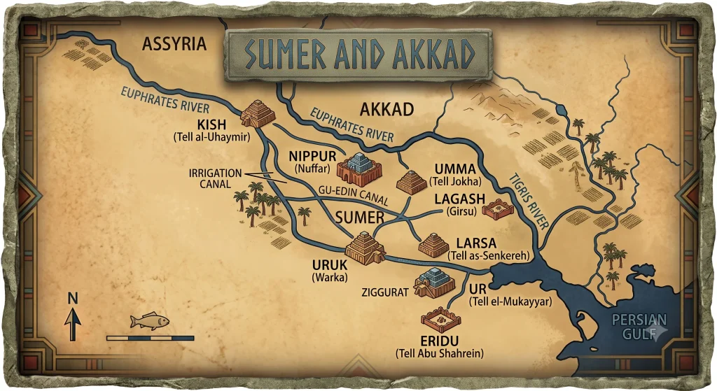
Chronological Table of Major Sumerian Cities
Below is an overview of the primary Sumerian city-states that established the foundations of global urbanization:
| Ancient City (Cuneiform) | Modern Site (Iraq) | Patron Deity | Zenith Period | Archaeological Significance & Key Artifacts |
| Eridu (Nun.ki) | Tell Abu Shahrein | Enki (God of Wisdom & Waters) | Ubaid Period (c. 5400–4000 BCE) | Traditionally regarded as humanity’s oldest city; 18 stratified temple phases of the E-abzu. |
| Uruk (Unug) | Warka | Inanna (Ishtar) & Anu (Sky God) | Uruk Period (c. 4000–3100 BCE) | The world’s first metropolis (40,000+ residents); origin of cuneiform writing and cylinder seals; the Warka Vase. |
| Ur (Urim) | Tell el-Mukayyar | Nanna / Sin (Moon God) | Early Dynastic III & Ur III (c. 2112–2004 BCE) | The Great Ziggurat of Ur-Nammu; Royal Cemetery gold treasures (excavated by Sir Leonard Woolley). |
| Nippur (Nibru) | Nuffar | Enlil (Supreme God of Wind & Decree) | 3rd to 2nd Millennium BCE | The sacred, non-political religious capital of Sumer; site of the holy E-kur temple and major scribal schools. |
| Lagash (Lagaš) | Tell al-Hiba / Girga | Ningirsu (God of Agriculture & War) | Early Dynastic III (c. 2500–2350 BCE) | The Stele of the Vultures (King Eannatum); administrative legal reforms of Urukagina; Gudea statues. |
| Kish (Kiš) | Tell al-Uhaymir | Zababa (Warrior God) | Early Dynastic II–III (c. 2900–2600 BCE) | Primeval seat of royal hegemony after the Great Flood (“King of Kish” became a supreme title of imperial authority). |
| Umma (Gisha) | Tell Jokha | Shara (God of War & Pastures) | Early Dynastic III (c. 2600–2350 BCE) | Centuries-long territorial border wars against Lagash over the fertile Gu-Edin plain; ruled by Lugalzagesi. |
| Larsa (Ararwa) | Tell as-Senkereh | Utu / Shamash (Sun God of Justice) | Isin-Larsa Period (c. 2000–1763 BCE) | Dominant political and trading hub prior to Hammurabi’s Babylonian conquests; the E-babbar temple. |
Visual Summary: The Anatomy of a Sumerian City-State
Zonification & Core Institutions of the Sumerian City-State (Uru)
- Sanctuary of the patron city deity
- Central grain granaries and ration distribution
- Scribal school archives (Edubba)
- Residence of the military ruler (Lugal)
- Judicial courts and royal garrison
- Tax registers and corvée labor organization
- River barge wharves connecting to Euphrates
- Customs houses and merchant guilds (Tamkārum)
- Workshops for pottery, metal, and textiles
What Defined a Sumerian City as an “Advanced City”?
In historical and archaeological curricula, Sumer is recognized as the classic model of an advanced civilization due to six distinctive urban criteria:
- Massive Population Density: Cities like Uruk enclosed over 250 hectares, sheltering between 20,000 to 50,000 citizens within defensive walls—an unprecedented density for the fourth millennium BCE.
- Complex Institutional Specialization: The separation of sacred cultic authority (The Temple / En), civil executive power (The Palace / Lugal), and merchant collectives (Karum).
- Cuneiform Written Record-Keeping: Writing was invented in Uruk to audit agrarian tribute, redistributive barley rations, and property boundary deeds on wet clay tablets.
- Hydraulic Engineering Infrastructure: Systematic networks of drainage ditches, dikes, and gravity-fed irrigation canals diverted Euphrates floodwaters across arid soils.
- Monumental Mud-Brick Architecture: Utilizing sun-dried and bitumen-mortared baked bricks to construct multistory monumental platforms (ziggurats) and royal palaces.
- Long-Distance Resource Commerce: Lacking indigenous metal ores, timber, and hard stone, Sumerian cities exported woven textiles and dates to import cedar from the Levant, copper from Dilmun/Oman, and lapis lazuli from Badakhshan.
In-Depth Analysis of Key Sumerian Cities
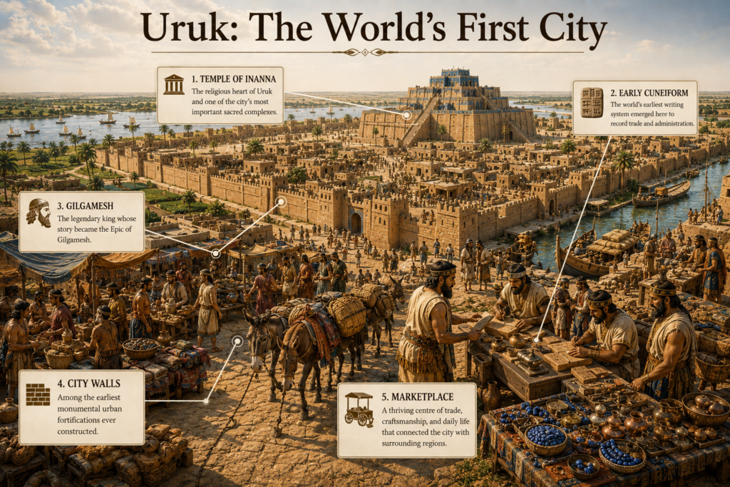
Uruk: The Birthplace of Global Urbanism
Occupying the apex of fourth-millennium development, Uruk (Warka) featured two monumental precinct centers: the Eanna District (dedicated to Inanna, goddess of love and war) and the Anu Ziggurat (crowned by the famous White Temple). Uruk pioneered mass-produced pottery (beveled-rim bowls used for standardized grain rations) and standardized clay cylinder seals to verify administrative property.
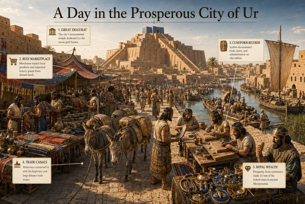
Ur: Wealth, Trade, and the Neo-Sumerian Renaissance
Positioned near the confluence of the Euphrates and the Persian Gulf, Ur commanded maritime commerce with Dilmun (Bahrain) and Magan (Oman). Under King Ur-Nammu and his successor Shulgi during the Third Dynasty of Ur (c. 2112–2004 BCE), Ur established the world’s earliest surviving legal code (The Code of Ur-Nammu) and erected the Great Ziggurat of Nanna, a three-tiered monument engineered with sophisticated weeping holes to drain moisture from its core.
Eridu: The Primeval Sacred Mound
Excavations at Eridu (Tell Abu Shahrein) by Fuad Safar and Seton Lloyd revealed a continuous stratigraphic sequence of 18 superimposed mud-brick temples dedicated to Enki. Beginning as a tiny one-room shrine around 5400 BCE, Eridu demonstrated the uninterrupted architectural evolution of Mesopotamian sacred architecture over three thousand years.
Lagash and Girsu: Military Might and Legal Reform
The city-state of Lagash was renowned for its administrative center at Girsu (Tello). In the mid-third millennium BCE, King Eannatum celebrated his victory over the neighboring city of Umma by carving the Stele of the Vultures, which contains the earliest visual depiction of a disciplined, helmeted infantry phalanx in human history. Later, King Urukagina (c. 2350 BCE) issued the first recorded social reforms aimed at protecting widows, orphans, and poor farmers from aristocratic extortion.
A Step into the Ancient World: Walking the Streets of Uruk
Step through the massive mud-brick northern gates of Uruk around 2900 BCE. The smell of burning bitumen and baked clay fills the morning air.
Narrow, shadowed alleys weave between high, whitewashed mud-brick walls without windows, shielding family courtyards from the searing desert heat. Farmers drive laden donkeys carrying sacks of dried emmer wheat, while potters in the artisan quarter stack cone-molded cups beside roaring kilns.
Ascending the wide brick ramp toward the Eanna Temple, you overlook the vast alluvial plain. From this height, the city reveals its genius: canal waters glisten as they branch through lush date palm orchards, feeding a bustling harbor where reed boats and wooden river barges unload copper ingots and cedar trunks. Scribes seated in the temple courtyard press wedge-tipped reeds into moist clay tablets, cataloging the daily rations of an entire urban civilization.
To understand how Sumer’s agricultural wealth sustained these metropolises, explore our detailed guide on Sumerian Economy.
Key Takeaways
- The City-State Framework: Ancient Sumer was never a single unified nation; it comprised autonomous city-states (uru) unified by culture, religion, and cuneiform writing.
- Uruk’s Primacy: Uruk emerged as humanity’s first true metropolis, developing writing, cylinder seals, and monumental civic planning.
- The Sacred Core: At the center of every city stood the Ziggurat and temple complex, which operated as a religious sanctuary, administrative treasury, and ration distributor.
- Hydraulic Engineering: Urban prosperity relied entirely on state-maintained canals diverting river water to produce massive barley surpluses.
- The Decline: Soil salinization from over-irrigation, shifting river courses, and imperial conquest by Sargon of Akkad (c. 2334 BCE) gradually transferred regional hegemony northward to Babylon.
Frequently Asked Questions About Sumerian Cities
Why is a Sumerian city-state called an independent entity?
A Sumerian city-state is considered independent because it possessed its own fortified city walls, autonomous government headed by a king (Lugal or Ensi), a dedicated patron deity, an independent scribal administration, and direct control over its surrounding agricultural territory.
What was the very first city in ancient Mesopotamia?
According to both Mesopotamian mythology and archaeological evidence, Eridu (founded c. 5400 BCE during the Ubaid Period) is recognized as the oldest permanent settlement, while Uruk (c. 4000 BCE) is universally recognized as the world’s first true large-scale metropolis.
What are the main characteristics of an advanced Sumerian city?
Advanced Sumerian cities featured large population concentrations, complex religious and political institutions (Temples and Palaces), specialized labor (merchants, scribes, bronze-smiths), cuneiform record-keeping, monumental architecture (Ziggurats), and canal irrigation infrastructure.
Why were Sumerian cities built near rivers?
Sumerian cities were established along the Euphrates and Tigris rivers because southern Mesopotamia received minimal annual rainfall. River waterways supplied essential drinking water, enabled canal irrigation for agriculture, and served as primary highways for trade barges.
What led to the decline of the Sumerian city-states?
The decline was driven by environmental factors (gradual soil salinization from thousands of years of irrigation and shifting Euphrates river channels) alongside military conquests by the Akkadian Empire (c. 2334 BCE) and the subsequent rise of the Amorite dynasties in Babylon.
Further Reading & Academic Sources
- The British Museum — Mesopotamian Cities and ArchaeologyArtifacts, cuneiform building inscriptions, and royal grave goods from Ur and Uruk.
- The Oriental Institute (ISAC) — University of Chicago Excavations at NippurComprehensive archaeological reports on the scribal schools and temple complexes of Nippur.
- UNESCO World Heritage Centre — The Ahwar of Southern Iraq (Uruk, Ur, and Eridu)Official World Heritage documentation on the preservation and cultural significance of southern Mesopotamian urban sites.
- Cuneiform Digital Library Initiative (CDLI)Digital open-access repository of thousands of administrative tablets from Early Dynastic Sumerian cities.