Piercing the massive northern wall of the Old City, Herod’s Gate often goes unnoticed by casual tourists who favor the monumental Damascus Gate just a short walk to the west. However, for historians and archaeologists exploring the fortifications of Jerusalem, this modest entrance offers a fascinating window into the city’s complex linguistic evolution and its violent medieval past. Serving as a primary artery into the bustling Muslim Quarter, the gate stands as a living monument to architectural adaptation and historical misunderstandings.
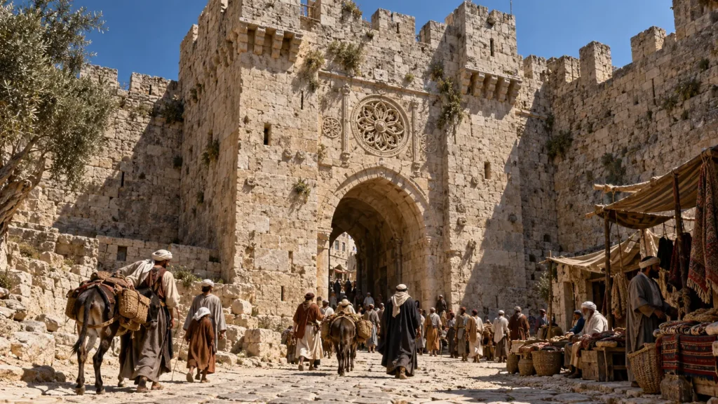
What is Herod’s Gate? (Bab az-Zahra & Bab as-Sahira)
Located on the northern perimeter of the Old City walls, Herod’s Gate is one of the newest public entrances in its current form, having only been opened to modern pedestrian and vehicular traffic in the late 19th century. To the local Palestinian population, however, the name “Herod” is rarely used. Instead, the portal is known by two distinct Arabic names that reveal a deep connection between the city’s architecture and Islamic eschatology: Bab az-Zahra and Bab as-Sahira.
The Gate of Flowers and the Floral Rosette
In modern Arabic, the entrance is most commonly referred to as Bab az-Zahra, which translates beautifully to the Gate of Flowers.
This name is not merely poetic; it is directly tied to the gate’s physical architecture. If you stand outside the portal and look closely at the limestone facade directly above the main arch, you will notice a distinct, finely carved floral rosette. This decorative stone element, a hallmark of 16th-century Ottoman masonry, became the defining visual feature for locals passing through it daily. Today, the bustling commercial neighborhood located immediately outside this entrance in East Jerusalem has also adopted the name, known officially as the Bab a-Zahra neighborhood.
Bab as-Sahira: The Cemetery of the Awakened
Yet, “Gate of Flowers” is actually a linguistic corruption of a much older and more profound name. The original Arabic name for this entrance is Bab as-Sahira.
In Islamic tradition, the term Sahira refers to a plain or a place of gathering where the dead will awaken on the Day of Resurrection. This solemn name was directly inspired by the geography immediately outside the walls. Just opposite the gate lies a prominent hill housing an ancient Muslim cemetery, where the faithful have been buried for centuries in anticipation of the Last Judgment. Over the centuries, due to phonetic similarities in the local dialect, the profound theological name Sahira (The Awakened) morphed into the visually fitting Zahra (Flowers), aided by the stone rosette above the arch.
Aquí tienes el bloque sobre el error de los Cruzados. Esta es la parte donde realmente demostramos autoridad académica (E-E-A-T). A los lectores apasionados por la historia bíblica les encanta descubrir que los nombres que llevan usando toda la vida provienen de malentendidos medievales.
En el H3, corregimos el error basándonos en la arqueología real (Flavio Josefo y excavaciones modernas) para ubicar el verdadero palacio de Herodes.
Why is it Called Herod’s Gate? (The Crusader Mistake)
Given that the local Arab population refers to it through the lens of flowers and resurrection, why is it universally known in English and Western literature as Herod’s Gate? The answer lies in a massive geographical misunderstanding perpetrated by European pilgrims during the Middle Ages.
When the Crusaders conquered Jerusalem in 1099 and established their kingdom, they were intensely eager to map the events of the New Testament onto the physical landscape of the city. According to the Gospel of Luke (23:7), during the trial of Jesus, Pontius Pilate learned that Jesus was a Galilean and sent him to be questioned by Herod Antipas, who was in Jerusalem for the Passover festival.
Looking for physical evidence of this event, 12th-century Crusader pilgrims erroneously identified a ruined building near this northern section of the wall (close to the present-day Greek Orthodox Church of St. Nicodemus) as the palace of Herod Antipas. Consequently, they began calling the small postern gate nearby “Herod’s Gate”—a misnomer that stubbornly stuck in Western literature and maps for centuries.
The True Location of Herod Antipas’s Palace
Modern archaeology and historical records have definitively proven the Crusaders wrong. So, where did the biblical encounter actually take place?
Historical accounts from the 1st-century Romano-Jewish historian Flavius Josephus, combined with extensive modern excavations, confirm that the royal palace built by Herod the Great—and utilized by his son Antipas when visiting the capital—was nowhere near the northern wall. The sprawling, luxurious Herodian palace complex was actually situated on the western ridge of the upper city, directly adjacent to the modern-day Jaffa Gate and the Citadel (the Tower of David). Despite this archaeological certainty, the Crusader mistake became permanent, and the northern gate carries the Herodian title to this day.
History of the Gate: From the First Crusade to Ottoman Rule
While the physical archway we see today dates back to the Ottoman Empire, the specific stretch of the northern wall where Herod’s Gate is located has been the site of some of the most decisive and violent military engagements in Jerusalem’s history. Because the city lacks deep natural valleys to the north, this section of the fortifications was historically the most vulnerable to heavy siege tactics.
The 1099 Crusader Breach (Godfrey of Bouillon)
This vulnerability was ruthlessly exploited during the First Crusade. In the sweltering summer of 1099, the Crusader armies laid siege to the Holy City. Recognizing that the northern wall was the most advantageous point of attack, the Frankish commander Godfrey of Bouillon concentrated his forces just east of the Damascus Gate—in the exact vicinity of the modern Herod’s Gate.
On July 15, 1099, after weeks of grueling combat, Godfrey’s troops successfully rolled a massive wooden siege tower against the fortifications here. The Crusaders breached the wall at this specific spot, pouring into the city and initiating the brutal conquest of Jerusalem. The blood-soaked legacy of this breach makes this quiet section of the wall a monumental site for medieval military historians.
Suleiman’s Original 16th-Century Postern
When the Ottoman Sultan Suleiman the Magnificent ordered the complete reconstruction of Jerusalem’s ruined walls between 1537 and 1541, his architects did not design Herod’s Gate to be a major thoroughfare.
Originally, the Ottomans constructed it as a narrow, unassuming postern (a secondary wicket gate). To maximize its defensive capabilities, the entrance did not open straight into the city. Instead, it was built into the eastern face of a protruding watchtower. Anyone entering had to walk through the small door, turn sharply 90 degrees to the right, and then proceed into the city—a classic L-shaped defensive design meant to slow down charging enemy troops and cavalry.
The 1875 Expansion and the New Facade
For over three centuries, the gate retained this narrow, heavily fortified layout. However, by the late 19th century, Jerusalem was experiencing a massive demographic shift. The city was expanding rapidly beyond its ancient walls, and the bustling new Bab a-Zahra neighborhood was developing immediately to the north.
To accommodate the growing pedestrian traffic and the need for easier access into the Muslim Quarter, the Ottoman authorities made a drastic architectural change in 1875. They permanently sealed up the original eastern-facing postern entrance and dramatically breached the frontal, northern face of the watchtower. They created the wide, direct entryway that visitors use today, transforming the ancient military postern into a functional public gateway.
The Architecture and Defensive Design
When analyzing the fortifications of Jerusalem, Herod’s Gate stands as a prime example of how Ottoman military architecture adapted older structures to fit modern needs. Unlike the Damascus Gate, which projects outward with overwhelming monumentality, this entrance is integrated directly into one of the massive square watchtowers that punctuate the northern wall.
The Limestone Rosette and the Tower
The current frontal entrance, opened during the 1875 expansion, cuts straight through the thickest part of the defensive tower. Despite its relatively modest size compared to other gates, the architecture retains several classic Ottoman defensive elements. High above the archway, the wall is crowned with crenellations (the notched battlements used by archers and guards).
However, the most striking architectural feature remains the intricate limestone rosette carved directly above the arch. This delicate floral motif, which inspired the Arabic name Bab az-Zahra, serves as a beautiful juxtaposition against the heavy, unyielding ashlar masonry of the military tower. If you look closely at the eastern wall of this protruding tower, you can still clearly see the faint outline of the original, sealed 16th-century postern door, standing as a physical ghost of the city’s older defensive layout.
Archaeological Context: The Ancient Moat
For archaeologists, the ground immediately outside Herod’s Gate is just as important as the stones of the wall itself. Because the northern perimeter of Jerusalem lacks the deep, natural defensive ravines found in the south (Valley of Hinnom) and the east (Kidron Valley), ancient and medieval engineers had to artificially create a barrier to protect the walls from siege engines.
Excavating the Crusader Fosse
To defend this vulnerable northern flank, a massive dry moat—known as a fosse—was carved directly into the solid bedrock running parallel to the wall. This monumental trench was heavily utilized during the Crusader and Ayyubid periods.
When Godfrey of Bouillon attacked in 1099, his first major engineering challenge was literally filling in a section of this immense moat so his siege towers could roll up to the walls at this exact location. Today, much of this ancient trench has been filled in, paved over by modern streets, or transformed into the sunken gardens and walkways that run along the outer perimeter of the Old City. However, extensive excavations by the Israel Antiquities Authority near Herod’s Gate continue to uncover sections of this formidable bedrock moat, reminding historians of the massive earthworks required to defend the Holy City.
Where is Herod’s Gate Located? (Map & Directions)
If you are navigating the perimeter of the Old City with a map, you will find Herod’s Gate positioned on the northern wall. It sits roughly halfway between the monumental Damascus Gate to its west and the northeastern corner of the city walls (known as the Stork Tower or Burj al-Laqlaq).
Because it is located slightly further away from the main tourist hubs of West Jerusalem, the area immediately outside the gate is distinctly local. It opens directly into the vibrant East Jerusalem neighborhood of Bab a-Zahra, serving as a primary transit point for Palestinian residents, merchants, and students.
Accessing the Muslim Quarter
For travelers entering the city, this gate offers one of the most authentic and unvarnished experiences of the Old City. Stepping through the arched portal brings you directly into the northern section of the Muslim Quarter.
Unlike the heavily commercialized tourist alleys near the Jaffa Gate, the streets winding south from Herod’s Gate are residential and filled with local markets, bakeries, and grocers serving the daily needs of the inhabitants. From here, a short walk south through the winding, stone-paved alleys will eventually lead pilgrims and visitors toward the Via Dolorosa and the esplanade of the Temple Mount.
Study Guide & Quick Answers (FAQs)
What is Herod’s Gate called in Spanish?
In Spanish-speaking academic literature and tourism guides, it is translated directly as la puerta de Herodes (Jerusalén). However, many specialized historical texts also refer to it by its Spanish-translated Arabic name, la Puerta de las Flores (The Gate of Flowers).
Why did the Crusaders name it Herod’s Gate?
Following the conquest of Jerusalem in 1099, Crusader pilgrims mistakenly identified a nearby ruined building as the palace of Herod Antipas, where Jesus was sent by Pontius Pilate during his trial. Modern archaeology has proven this incorrect, as the actual Herodian palace was located on the western side of the city near the modern Jaffa Gate.
What does Bab az-Zahra mean?
Bab az-Zahra is the modern Arabic name for the gate, translating to “Gate of Flowers.” It refers to the intricate floral rosette carved in limestone above the archway. It is a linguistic evolution of the older name Bab as-Sahira, which means “The Awakened,” referring to the nearby cemetery and the Islamic Day of Resurrection.